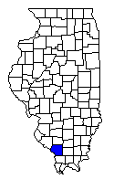
Beaucoup Settlement is in Jackson county, twelve miles
northeast from Brownsville, between the Big Beaucoup creek and Big Muddy
river. The land is rich, heavily timbered, with a considerable settlement.
Big Muddy River, (called by the French who discovered
it, Riviera au Vase, or Vaseux,) a considerable stream in the southwestern
part of the state. It has four principal heads, which, rising in Washington
Jefferson, and Hamilton counties, and uniting in Jackson county, form the
main stream. They are the Beaucoup, Little Muddy, and Middle Fork. The
general course of the stream is southwest, and it is navigable some distance
above Brownsville. Below Brownsville it turns south to the county line,
makes a short bend, and enters the Mississippi near the northeastern corner
of township eleven south, in range four west of the third principal
meridian. Its bluffs generally are abrupt, the land along its borders and
branches undulating, and for most of its length well timbered. Valuable
salines exist on its banks and are worked about Brownsville, where there is
an inexhaustible bed of bituminous coal. Native copper has been found on its
banks in detached masses. It runs through a fine agricultural and grazing
country.
Bradley's Settlement is at the head of Kincaid creek, in the
north part of Jackson county. It is a timbered region, tolerable land, and
has twenty-five or thirty families.
BROWNSVILLE, the
seat of of justice for Jackson county, is situated on the north side of Big
Muddy river, on section two, nine south, and three west of the third
principal meridian. It is twelve miles by land, and twenty-five by water
from the Mississippi, and is surrounded by hills. The Big Muddy Salines and
coal banks are near this place. The population is about twenty families.
Cedar Creek, a branch of Big Muddy river in Jackson
county, rises in Union county, and runs first north, and then a western
course, and enters Muddy river twelve miles above its mouth. This creek has
high bluffs towards its mouth, which abound with cedar. The country is
broken, timbered, well watered with springs, and contains about one hundred
families. The main settlement is six miles from Brownsville.
Columbo Creek rises in Perry county, runs a southeast course, and
enters Big Beaucoup, in Jackson county.
Cox's Prairie,
northeast of Brownsville, in Jackson county, near Big Beaucoup, contains
about four sections of good rolling land.
Crab Orchard,
a small creek that rises in the south part of Franklin county, passes into
Jackson, and enters the Big Muddy, fifteen miles above Brownsville. The
country adjoining is level and good, and the settlement has forty or fifty
families.
Devil's Oven is a singular promontory of
sand rock that projects into the Mississippi, in Jackson county, one mile
above the Grand Tower. It has a cave resembling the month of a mammoth oven,
to be seen from the river.
Drewry's Creek, a branch
of Crab Orchard. It rises in Union County, runs a devious course
northeasterly into Jackson county, and has a settlement of fifteen or twenty
families. The land timbered, and second rate soil.
Fountain
Bluff, frequently called the "Big Hill" in Jackson county. It is a
singularly formed eminence, or rocky bluff on the Mississippi, six miles
above the mouth of the Big Muddy river. It is of an oval shape, eight miles
in circumference, and with an elevation of 300 feet. The western side is on
the river, and the top is broken full of sink holes, with shrubs and
mattering timber. The north side is nearly perpendicular rock, but the south
side is sloping, and ends in a fine rich tract of soi1, covered with farms.
East is an extensive and low bottom with lakes and swamps. Fine springs of
limpid water gush out from the foot of this bluff on all sides. North, and
along the bank of the Mississippi, is dry and rich alluvion with a line of
farms, known by the name of the "Settlement under the Bluff."
Gagnie, a sluggish stream that runs southwest into the
Mississippi, and forms the boundary line between Randolph and Jackson
counties.
Grand Prairie. Under this general name is
embraced the prairie country lying between the waters which fall into the
Mississippi, and those which enter the Wabash rivers. It does not consist of
one vast tract, boundless to the vision, and uninhabitable for want of
timber; but is made up of continuous tracts, with points of timber
projecting inward, and long arms of prairie extending between the creeks and
smaller streams. The southern joints of the Grand prairie are formed in the
northeastern parts of Jackson county, and extend in a northeastern course
between the streams of various widths, from one to ten or twelve miles,
through Perry, Washington, Jefferson, Marion, the eastern part of Fayette,
Effingham, through the western portion of Coles, into Champaign and Iroquois
counties, where it becomes connected with the prairies that project eastward
from the Illinois river and its tributaries. A large arm lies in Marion
county, between the waters of Crooked creek and the East fork of the
Kaskaskia river, where the Vincennes road passes through in its longest
direction. This is frequently called the Grand prairie. Much the largest
part of the Grand prairie is gently undulating; but of the southern portion
considerable tracts are flat, and of rather inferior soil. No insurmountable
obstacle exists to its future population. No portion of it is more than six
or eight miles distant from timber, and coal in abundance is found in
various parts. Those who have witnessed the changes produced upon a prairie
surface within twenty or thirty years, consider these extensive prairies as
offering no serious impediment to the future growth of the state.
Lewis's Creek, a trifling stream in Jackson county, enters
Big Muddy near the coal bank four miles east of Brownsville.
Little Muddy is one of the four heads of the Big Muddy river. It
rises in the southeastern corner of Washington county, crosses the line into
Jefferson, then into Franklin and finally into Jackson, where it enters the
parent stream on the right side, in section thirteen, eight south, one west.
A post office. It has good timber and prairie on both sides.
Marshall's Prairie, north of Cox's prairie, fourteen miles
northeast of Brownsville, in Jackson county, is rich, undulating land, and
the settlement contains a dozen families.
Mount Carbon,
a coal bank on Muddy river, four miles above Brownsville, in Jackson county.
Large quantities are exported from this place down the river. Here is a
large steam saw and grist mill.
Pinus, a post office
in Jackson county, on section thirty-four, township ten south, two west,
twelve miles south-southeast from Brownsville.
Ridge
Settlement lies in Union county, on the road to Brownsville, and
extends into Jackson county. It is a high, hilly, timbered tract of good
land, well watered, and has from one hundred to one hundred and fifty
families.
Extracted from A Gazetteer of Illinois; in Three Parts, author J. M. Peck, published in 1837.
Randolph |
Perry | Franklin |
Perry MO |
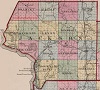 |
Williamson |
| Union |